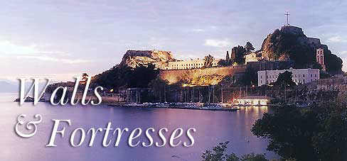
When
the Venetians conquered Corfu they began a great project of fortifications,
in an attempt to defend their acquisition from continuously increasing
raids (especially by the Turks). Within three centuries fortresses,
walls and underground tunnels had been constructed, some parts of
which survive today. 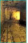 Apart
from the fortifications, the Venetians were responsible for general
improvements to the town, with buildings which continue to delight
the eyes of today's passers-by and provide constant inspiration for
the photographer. The French and the English, who continued the occupation
of the island, preserved these buildings, adding to them with their
own building techniques, with the result that the Corfu of today reflects
the building traditions of six centuries. The two great fortresses
were linked by two rows of walls, between which the townspeople lived
in safety. The northern sea-wall was called the 'Mourayia' a name
which lives on today in the part of town where remains of the wall
can still be seen. The southern wall started at the Old Fortress passing
by today's Aktaion Cafe, NAOK, the statue of Capodistria, the Phoenix
Theatre, the Gymnasium, and the Market, ending at the New Fortress. Apart
from the fortifications, the Venetians were responsible for general
improvements to the town, with buildings which continue to delight
the eyes of today's passers-by and provide constant inspiration for
the photographer. The French and the English, who continued the occupation
of the island, preserved these buildings, adding to them with their
own building techniques, with the result that the Corfu of today reflects
the building traditions of six centuries. The two great fortresses
were linked by two rows of walls, between which the townspeople lived
in safety. The northern sea-wall was called the 'Mourayia' a name
which lives on today in the part of town where remains of the wall
can still be seen. The southern wall started at the Old Fortress passing
by today's Aktaion Cafe, NAOK, the statue of Capodistria, the Phoenix
Theatre, the Gymnasium, and the Market, ending at the New Fortress.
Two other fortresses, one on Avrami Hill, one on Salvatore Hill,
completed the town fortifications. Of these, only the Salvatore
fortress remains today, however, only criminals can visit it as
it now houses the Prison. Four main gates in the city walls permitted
access to the city centre and to the sea. The first, the Spilia
Gate, is still to be seen facing the old port beside the Agricultural
Bank, and is known as the Bonati Arch. The second, the Saint Nicholas
Gate, is on the northern side of the Esplanade, at the base of the
walls below the level of the coastal road. The Porto Remounda was
on the southern side of the Esplanade, in the district of the same
name, and led to Garitsa. It was destroyed in the 19th century.
The fourth gate, the 'Royal' Gate (Porta Reale), shared the same
fate. It stood in G. Theotoki Street, next to the site of what used
to be the Pallas Cinema but all that now remains of it is the name
of the area - Porta Riala.
An impressive example of the Venetian infrastructure is the system
of subterranean communication throughout the town. The four fortresses
and certain central points in the town were linked by underground
tunnels, the so-called 'Mines'. Rumour has it that the tunnels reach
as far as the island of Vido. Most of the tunnels have now been
closed, either by building works or by subsidence. Those which might
still be functional have been closed on government orders: our penal
system is not so enlightened that it would leave open the tunnel
connecting the prison with Vido!
Old Fortress:
This was built by the Venetians upon the remains of a Byzantine
castle and was completed in two stages. During the first period
(1400-1500) the Venetians strengthened the Byzantine walls and 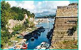 dug
the Contra Fossa moat, turning the promontory into an artificial
island accessed by a movable bridge. dug
the Contra Fossa moat, turning the promontory into an artificial
island accessed by a movable bridge.  In
more recent times the Contra Fossa became notorious as the classic
site of romantic suicides. The second period (16th-18th centuries)
began with the completion of this work (1546-1588) and ended with
the additions and alterations made by the British. Today two impressive
bastions remain, which bear the names of the Italian engineers Martinengo
and Savorgnan, as well as later British buildings and accretions,
such as the church of St. George, built in 1840 as a basilica with
Doric columns. Most of the churches and other buildings have however
been destroyed, most important amongst them the Palace of the Venetian
Proveditore. In
more recent times the Contra Fossa became notorious as the classic
site of romantic suicides. The second period (16th-18th centuries)
began with the completion of this work (1546-1588) and ended with
the additions and alterations made by the British. Today two impressive
bastions remain, which bear the names of the Italian engineers Martinengo
and Savorgnan, as well as later British buildings and accretions,
such as the church of St. George, built in 1840 as a basilica with
Doric columns. Most of the churches and other buildings have however
been destroyed, most important amongst them the Palace of the Venetian
Proveditore.
New Fortress:
Built between 1572 and 1645 by the Italian architect F. Vitelli,
on the hill of St. Mark, the inner buildings of the fortress were
constructed by the British. It consists of two massive twin bastions
and is considered to be 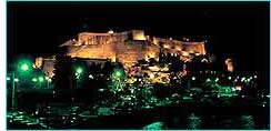 a
marvel of fortress architecture. It should be visited not least
for the magnificent view of the town and sea that it affords, preferably
in the late afternoon, when the heat is less intense. Recently restored,
it is often used by the municipal authorities of Corfu for exhibitions,
concerts and many other cultural activities ( for full details of
the programme of events contact the Municipal Information Office).
There is a bar/cafe within the fortress, and a 'gallerie' where
you may obtain various publications issued by the municipality,
prints, tourist guides and maps. In the wing on the left-hand side
of the first floor of the barracks there is an exhibition centre,
where interesting collections of paintings, sculpture and photographs,
by artists of international repute, are often displayed. The stairs
you ascend in order to penetrate into the Fortress lead to one of
the tunnels, which in turn leads to the centre of the town by way
of the local market-place. The area in which the market is located
was a 'dry moat', overlooked by ramparts and connected with the
Fortress as part of its fortifications. a
marvel of fortress architecture. It should be visited not least
for the magnificent view of the town and sea that it affords, preferably
in the late afternoon, when the heat is less intense. Recently restored,
it is often used by the municipal authorities of Corfu for exhibitions,
concerts and many other cultural activities ( for full details of
the programme of events contact the Municipal Information Office).
There is a bar/cafe within the fortress, and a 'gallerie' where
you may obtain various publications issued by the municipality,
prints, tourist guides and maps. In the wing on the left-hand side
of the first floor of the barracks there is an exhibition centre,
where interesting collections of paintings, sculpture and photographs,
by artists of international repute, are often displayed. The stairs
you ascend in order to penetrate into the Fortress lead to one of
the tunnels, which in turn leads to the centre of the town by way
of the local market-place. The area in which the market is located
was a 'dry moat', overlooked by ramparts and connected with the
Fortress as part of its fortifications.
|