Ano Korakiana: five kilometres from Agios
Markos and eighteen kilometres from Corfu Town , 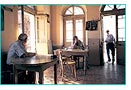 has
a population of 1400 and many buildings in traditional style.
It boats a Philharmonic Orchestra founded in 1958, underlining
the musical traditions which began in 1623 with the founding of
the Mandolinatas of the Pope. Out of its 37 churches, the ones
dedicated to Agios Nikolaos, the Archangel Michael and Agios Athanasios
are of great interest to Byzantine scholars. The local school,
a fine neo-Classical building, contains a small folklore collection.
has
a population of 1400 and many buildings in traditional style.
It boats a Philharmonic Orchestra founded in 1958, underlining
the musical traditions which began in 1623 with the founding of
the Mandolinatas of the Pope. Out of its 37 churches, the ones
dedicated to Agios Nikolaos, the Archangel Michael and Agios Athanasios
are of great interest to Byzantine scholars. The local school,
a fine neo-Classical building, contains a small folklore collection.
The Ropa Valley: stretches over a plain
of some 10,000 stremmata (about 2500 acres) towards the north
of the Mesis region. Long ago it was a lake, which was subsequently
drained, and today a great network of irrigation ditches and canals
carries away rainwater absorbed by the rich soil, by way of the
Ropa, or Ermones, River. Parts of the valley have been developed
for tourism, and there is a golf course and horse riding while
agriculture is essentially non-existent. With a lake close by
to the east, with its river flowing out to the sea at Ermones
Bay, the valley has become an important wetlands habitat, home
of a multitude of birds, reptiles, amphibians and fish. On the
low hills which completely surround the valley, agricultural villages
have been established, such as Kanakades, Marmaro, Giannades,
Tembloni and Vassilika.
Vatos: at fifteen kilometres from town,
is a small, quiet village with two interesting Byzantine churches,
Agios Nikolaos, with frescoes of the 13th century, and Agios Georgios,
built on the summit of the hill of the same name, with frescoes
of the 14th and 15th centuries.
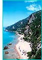 Myrtiotissa:
a rough, steep track runs down from Vatos to Myrtiotissa, a gorgeous
little beach which is the favourite of nudists. To the right (north)
of the beach is the Monastery of the Blessed Virgin of Myrtiotissa,
which was founded in the 14th century by a monk, a Turk who had
been converted to Christianity. It owes its name to an icon of
the Virgin which was found amongst the myrtle bushes. A coastal
path of great botanical interest leads from here to Ermones.
Myrtiotissa:
a rough, steep track runs down from Vatos to Myrtiotissa, a gorgeous
little beach which is the favourite of nudists. To the right (north)
of the beach is the Monastery of the Blessed Virgin of Myrtiotissa,
which was founded in the 14th century by a monk, a Turk who had
been converted to Christianity. It owes its name to an icon of
the Virgin which was found amongst the myrtle bushes. A coastal
path of great botanical interest leads from here to Ermones.
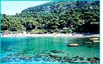
Ermones: is a small bay on Corfu’s
western coast, with sheer cliffs and wooded hills. Archaeological
excavations have uncovered the remains of a Bronze Age hamlet
here, testament to the existence of prehistoric settlers in the
area. Guests of the large hotel complex which is built on the
hillside can enjoy a wonderful beach, where cold, fresh water
flows from a river into the sea. But there is also plenty of room
for visitors, with rooms for rent, fish tavernas, and plenty of
bars.
Pelekas: twelve kilometres from town
and built near the summit of a beautiful hill at a height of 270
metres, the village is famed for its panoramic view and the splendid
sunsets. Here is the ‘Kaiser’s Throne’, where Kaiser
Wilhelm II used to come and meditate.
Glyfada: a huge and very popular sandy
beach with bars open round the clock, hotels, restaurants, and
crowds of people. This is where the panhellenic volley-ball championships
take place.
Kontoyialos: an outstanding beach, a smaller
version of Glyfada, with tavernas right at the water’s edge,
rooms for rent and a hotel. It can be reached by three different
roads.
Yialiskari: On the road which links Pelekas
with Sinarades you will find a turn-off to Yialiskari, a small
bay where pine trees run right to the water’s edge. There
are two or three tavernas, but also lots of visitors from the
hotel nearby.
Sinarades: is a large, well-preserved
village with buildings from the Byzantine and Venetian eras. Also
of interest in the village is a campanile dating from the 17th
century ( not the one in the square, which is a modern copy of
a Venetian one) and a little way further on, up an alley, is an
old bakery where bread is still made in the old way and baked
in wood-fired ovens. A philharmonic orchestra was founded in Sinarades
in 1960, and it takes part in all local events and processions.
Kastellani: was the capital of the region
until 1912. Prospero Marini, an Italian knight who had the monopoly
on the salt trade in the Ionian Islands until his death in 1694,
lived here. His will provided for the establishment of an intellectual
foundation, centred on the Church of the Blessed Virgin of the
Golden Spring (today called the Church of the Source of Life –
Zoodochos Pigi). The aim was to educate children from all over
Corfu. The foundation was a closed order and was overseen by ten
monks. The tomb of Marini, according to his wishes, is located
at the rear of the church. Near the village square is the once-private
Church of Agios Spiridon (St. Spiridon), which dates from 1730.
Icons from both these churches are on display at the Byzantine
Museum of Antivouniotissa.
Kamara: is located south of Kastellani,
and has a well with excellent drinking water. As well as Greeks,
Venetians who were out of favour with the authorities once lived
in Kamara, and the adjacent village of Alepohori was settled by
Cretan refugees. Near Kamara there are two Byzantine monasteries
in poor condition, Agios Taxiarchis (Archangel) and Agios Vlassios
(St. Blaise), with frescoes from the 13th, 16th and 17th centuries.

