Alykes: means salt pans. This is where
the Venetians used to exploit the salt pans, distributing the
produce to their colonies on the Dalmatian Coast. Here too the
Potamos River flows into the sea, with the estuary forming an
important wetlands habitat. Alykes is located 4 kilometres from
Corfu Town and has rooms for rent and some good hotels.
Kontokali: this area took its name from
the sea-captain Christophoros Kontokalis, who, in 1571 at the
Battle of Lepanto, captured a Turkish galley and was granted land
here as a reward. Around 1700 the Gerekos family arrived in the
region, and to this day live on the shores of the bay, involving
themselves, as they always have, with fishing.
Gouvia: 8 kilometres from town and almost
joined with Kontokali, is an old fishingvillage with an interesting
history. 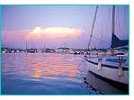 On
August 29th 1537 the Turkish fleet, under the command of the Corsican
Barbarossa, who was in the service of Suleiman the Magnificent,
landed at Gouvia, bringing ruin to the entire Mesis region. The
invading force, however, failed to take the Old Fortress, despite
a siege lasting twelve days. Two centuries later, they made another
landing at Gouvia (and at Pyrgi) again with the town as target,
but left after a month-long siege. The Corfiots attributed their
salvation to to St. Spiridon. Subsequently, the Venetians fortified
the harbour at Gouvia and built a shipyard to maintain and repair
their boats, while at the same time servicing passing vessels.
The columns and vaults which remain today stand as a reminder
of those long-gone years when the Serene Republic of Venice ruled
the eastern seas. Today it is the home of the Marina, which can
service 900 yachts. The marina is located in the central area
of the bay and separates the beaches of the two villages.
On
August 29th 1537 the Turkish fleet, under the command of the Corsican
Barbarossa, who was in the service of Suleiman the Magnificent,
landed at Gouvia, bringing ruin to the entire Mesis region. The
invading force, however, failed to take the Old Fortress, despite
a siege lasting twelve days. Two centuries later, they made another
landing at Gouvia (and at Pyrgi) again with the town as target,
but left after a month-long siege. The Corfiots attributed their
salvation to to St. Spiridon. Subsequently, the Venetians fortified
the harbour at Gouvia and built a shipyard to maintain and repair
their boats, while at the same time servicing passing vessels.
The columns and vaults which remain today stand as a reminder
of those long-gone years when the Serene Republic of Venice ruled
the eastern seas. Today it is the home of the Marina, which can
service 900 yachts. The marina is located in the central area
of the bay and separates the beaches of the two villages.
Potamos: 4 kilometres from town , is
a traditional village with arcades (kamares) which appear endless,
stretching the entire length of the main street. The river which
cuts through the village and the surrounding lush vegetation are
evidence that, in the years when agriculture was everything, Potamos
was an especially prosperous village. The Church of Agia Varvara
(St. Barbara) stands here, and its annual procession terminates
in Tembloni, 15 kilometres away. The procession is said to date
from a time of drought, as an invocation for rain.
Evropouli: is also a traditional village,
whose name reveals that it was founded by Jews (Evraioi in Greek)
in the 13th century. Near the village, on the road to Potamos,
is the Kapodistrias Mansion, which houses a museum containing
pictures and personal possessions of the first Greek President,
John Kapodistrias.
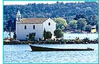 Kommeno:
The northern shores of Gouvia Bay are enclosed by the Kommeno
peninsula, a lovely spot with the tiny church of Ypapanti on its
islet in the waters of the bay. Although it is near Corfu Town,
and has a good beach and rich vegetation, it is not a haunt of
the masses, and for the discerning visitor offers quiet holidays
in luxury hotels with good restaurants.
Kommeno:
The northern shores of Gouvia Bay are enclosed by the Kommeno
peninsula, a lovely spot with the tiny church of Ypapanti on its
islet in the waters of the bay. Although it is near Corfu Town,
and has a good beach and rich vegetation, it is not a haunt of
the masses, and for the discerning visitor offers quiet holidays
in luxury hotels with good restaurants.
Dafnila, Dassia, Ipsos, Pyrgi: are
resorts with the same characteristics as Kommeno, but with  the
addition of busy tourist traffic and with every kind of restaurant,
bar and night-club. It is not a coincidence that six of the island’s
fifteen camping sites are located in this area. After Dassia,
the road descends to the long, straight seashore at Ipsos. Here
the atmosphere is lively round the clock, with every conceivable
type of watersport for daytime enjoyment, and a continuous strip
of bars for entertainment at night. Young people from all over
Europe fill the summer evenings with their crazy rhythm.
the
addition of busy tourist traffic and with every kind of restaurant,
bar and night-club. It is not a coincidence that six of the island’s
fifteen camping sites are located in this area. After Dassia,
the road descends to the long, straight seashore at Ipsos. Here
the atmosphere is lively round the clock, with every conceivable
type of watersport for daytime enjoyment, and a continuous strip
of bars for entertainment at night. Young people from all over
Europe fill the summer evenings with their crazy rhythm.
Merlin Estate: this is at Dassia, and
is the property of the Merlin family, a member of which, a well-known
English gardener, experimented and bred the orange varieties which
are named after him. It was also Merlin who brought the Kumquat
to Greece from Japan, and its fruit has become one of the trademarks
of Corfu.
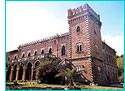 Castello:
A huge villa in Gothic style, once the residence of an Italian
baron, Luca Mimbelli. It was built by an Italian architect on
the site of a ruined medieval tower, and is located between Gouvia
and Dassia, just outside Kato Korakiana.
Castello:
A huge villa in Gothic style, once the residence of an Italian
baron, Luca Mimbelli. It was built by an Italian architect on
the site of a ruined medieval tower, and is located between Gouvia
and Dassia, just outside Kato Korakiana.
Agios Markos: is a village which must be visited. It is
on the threshold of desertion due to a landslide, and its old
houses are overgrown with the passage of the years. The Church
of the Pantokrator dates from 1576 and contains frescoes of the
same period. Located near the village, the Church of St. Merkourios
is, after the Church of St. Jason and St. Sosipatros in Anemomylos,
the most exceptional Byzantine monument on the island. Its rare
frescoes date from 1075 and reveal the true spirit of Byzantium
in the economy of their lines and in the expressiveness of the
gaze of the depicted saints.

