 Marathias:
5 kilometres beyond Argyrades, it was built at the start of the
20th century by residents of Old Marathias, which once stood opposite
on a hill to the east. In 1816, this area suffered an epidemic of
plague, and the governor ordered the destruction by fire of dwellings
hit by the pestilence. The result of this prophylactic official
intervention was that the village of Roumanades was completely destroyed,
while in Marathias a few houses were saved. The people decided to
abandon the ruined village, building instead the one which stands
today. Continuing along the road, we reach Perivoli, where the church
is dedicated to Agii Saranda (Forty Saints), and has frescoes dating
from 1704. Roads lead from Marathias and Perivoli to Maltas, a vast
beach with all the features of these southern shores – fine
sand and shallow water.
Marathias:
5 kilometres beyond Argyrades, it was built at the start of the
20th century by residents of Old Marathias, which once stood opposite
on a hill to the east. In 1816, this area suffered an epidemic of
plague, and the governor ordered the destruction by fire of dwellings
hit by the pestilence. The result of this prophylactic official
intervention was that the village of Roumanades was completely destroyed,
while in Marathias a few houses were saved. The people decided to
abandon the ruined village, building instead the one which stands
today. Continuing along the road, we reach Perivoli, where the church
is dedicated to Agii Saranda (Forty Saints), and has frescoes dating
from 1704. Roads lead from Marathias and Perivoli to Maltas, a vast
beach with all the features of these southern shores – fine
sand and shallow water.
 Vitalades:
is reached by way of a right turn off the main road just after
Perivoli, following the sign. Two separate roads lead to two different
beaches: Gardeno, where the river of that name flows into the
sea, and there are tavernas and a broad seashore; and Megalo Horo,
where you will find complete solitude.
Vitalades:
is reached by way of a right turn off the main road just after
Perivoli, following the sign. Two separate roads lead to two different
beaches: Gardeno, where the river of that name flows into the
sea, and there are tavernas and a broad seashore; and Megalo Horo,
where you will find complete solitude.
 Ringlades:
the first of the settlements which make up Lefkimmi, it must have
Byzantine roots, since its name derives from the Ringli family
which lived in the region in the Middle Ages. The village has
traditional mansions and smaller houses built in simple style,
as well as two churches of Byzantine origin, Agii Anaryiri and
Agios Arsenios. Ringlades has a very active philharmonic orchestra
whose band, choir and dance section lead a traditional festival
of great note on 15th August, not to be missed for anything.
Ringlades:
the first of the settlements which make up Lefkimmi, it must have
Byzantine roots, since its name derives from the Ringli family
which lived in the region in the Middle Ages. The village has
traditional mansions and smaller houses built in simple style,
as well as two churches of Byzantine origin, Agii Anaryiri and
Agios Arsenios. Ringlades has a very active philharmonic orchestra
whose band, choir and dance section lead a traditional festival
of great note on 15th August, not to be missed for anything.
Anaplades: situated beside Ringlades,
on the road leading towards the sea. There are two theories to
explain the origin of its name – according to one, it was
founded in 1540 by soldiers from Nauplio (Anapliots), who were
fleeing from the Turks. The other theory suggests it has its roots
in the old, probably Byzantine, Anopoulaios family.
 Alykes:
is located on the Lefkimmi promontory, where the lighthouse, a
familiar landmark for sailors, welcomes from afar visitors to
the island. Here in the 15th century, a salt extraction business
was established, which was in operation until quite recently.
Buildings and installations of that period still stand, restored
and ready to open as a museum.
Alykes:
is located on the Lefkimmi promontory, where the lighthouse, a
familiar landmark for sailors, welcomes from afar visitors to
the island. Here in the 15th century, a salt extraction business
was established, which was in operation until quite recently.
Buildings and installations of that period still stand, restored
and ready to open as a museum.
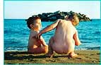
Molos: is the name of the beach next
to Alykes, the place where from long ago, the fishing boats have
always moored to allow the fishermen to clean their nets. At dawn
you can watch them come in with their baskets full – a fine
opportunity to pick up some really fresh fish. These two beaches,
with their fine sand and shallow waters, are ideal for family
holidays.
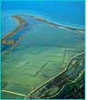
 Potami:
a true river which drains the water from the plain of Lefkimmi,
eastward to its outflow at the sea. The Lefkimmi River passes
through the town of the same name, running beneath a picturesque
bridge, where fishermen tie up their boats, a safe refuge during
a hard winter. Small boys dangle fishing lines over the bridge,
and Kyra-Maria has a small taverna where she cooks home-style,
with red pepper and local olive oil, serving her dishes with Lefkimmi
wine and seasoning them with a running commentary of anecdotes
related in a remarkably vulgar dialect! This river, mentioned
in archives since 1618, has known great glories. It used to be
the chief means of transporting local agricultural produce to
the sea, and from there to the town of Corfu or to the Epirot
mainland, but its usefulness declined gradually from 1970, with
the improvements to the island’s road network. At its outflow
at Bouka there is a small port where at one time a dockyard functioned.
Today, beside this unspoiled, environmentally-protected beach,
there is a canteen run by the local community, and a children’s
playground, where beach-volley competitions are often organised.
Potami:
a true river which drains the water from the plain of Lefkimmi,
eastward to its outflow at the sea. The Lefkimmi River passes
through the town of the same name, running beneath a picturesque
bridge, where fishermen tie up their boats, a safe refuge during
a hard winter. Small boys dangle fishing lines over the bridge,
and Kyra-Maria has a small taverna where she cooks home-style,
with red pepper and local olive oil, serving her dishes with Lefkimmi
wine and seasoning them with a running commentary of anecdotes
related in a remarkably vulgar dialect! This river, mentioned
in archives since 1618, has known great glories. It used to be
the chief means of transporting local agricultural produce to
the sea, and from there to the town of Corfu or to the Epirot
mainland, but its usefulness declined gradually from 1970, with
the improvements to the island’s road network. At its outflow
at Bouka there is a small port where at one time a dockyard functioned.
Today, beside this unspoiled, environmentally-protected beach,
there is a canteen run by the local community, and a children’s
playground, where beach-volley competitions are often organised.
Melikia: this is the next village, which
owes its name to the Meliki family, who lived there from the 15th
century. Here you should visit the church of Agios Isavros, which
has rare wall frescoes and icons from the 16th century. From Melikia
a road leads to the new Port of Lefkimmi , with ferry connections
to Igoumenitsa (10 nautical miles – one hour), offering an
alternative port of entry and exit for the island.
 Kavos:
a modern tourist resort with tavernas and restaurants, clubs and
bars, and a busy beach, a magnet for young people from all over
the world, especially from Britain. It is a place which offers
frenetic activity all day long. Boats leave from Kavos for Paxos,
Antipaxos and Sivota. On 8th July the festival of the church of
Agios Prokopios takes place, with a procession the evening before
in which the Bishop of Corfu and the local philharmonic orchestras
participate. Away from the busy centre of Kavos, it is easy to
find secluded spots amongst the olive groves, places such as Evyeniadis,
Armeno, and Pantatika, all of which are most attractive to families.
Kavos:
a modern tourist resort with tavernas and restaurants, clubs and
bars, and a busy beach, a magnet for young people from all over
the world, especially from Britain. It is a place which offers
frenetic activity all day long. Boats leave from Kavos for Paxos,
Antipaxos and Sivota. On 8th July the festival of the church of
Agios Prokopios takes place, with a procession the evening before
in which the Bishop of Corfu and the local philharmonic orchestras
participate. Away from the busy centre of Kavos, it is easy to
find secluded spots amongst the olive groves, places such as Evyeniadis,
Armeno, and Pantatika, all of which are most attractive to families.
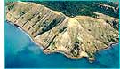
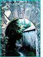 Arkoudillas:
located at the southernmost tip of Corfu, this is in complete
contrast to Kavos. A dense forest of cypress trees and shrubs
covers some 250 stremmata (80 acres),bringing to mind the perfect
setting for myths and fairy-tales. A walk amidst the luxuriant
vegetation in the depths of the seemingly endless woods, is ideal
at any time of day, and you can take as long as you need to find
Little Red Riding Hood. The forest ends at a sheer cliff overlooking
the sea, where the view of Asprokavos headland takes the breath
away. The name Arkoudillas comes from the French ‘arc de
l’isle’ – the island’s archway, an idiom referring
to the farthest edge of land, while in ancient times it was called
Amphipagas. The Monastery of the Blessed Virgin, dating from 1700,
is located here, with its walls and fortifications, with the storerooms
of the monks and secret trapdoors. The former overlords of the
area, the Quartano family, have left their mark in the form of
their family emblem, showing the Lion of Venice, an ear of maize,
grapes and a pomegranate. By way of a narrow footpath you can
descend to the deserted beach, to swim in crystal-clear water.
Beyond Arkoudillas, the beach of Ai-Gordis is for those who believe
nature to be the most important aspect of our existence.
Arkoudillas:
located at the southernmost tip of Corfu, this is in complete
contrast to Kavos. A dense forest of cypress trees and shrubs
covers some 250 stremmata (80 acres),bringing to mind the perfect
setting for myths and fairy-tales. A walk amidst the luxuriant
vegetation in the depths of the seemingly endless woods, is ideal
at any time of day, and you can take as long as you need to find
Little Red Riding Hood. The forest ends at a sheer cliff overlooking
the sea, where the view of Asprokavos headland takes the breath
away. The name Arkoudillas comes from the French ‘arc de
l’isle’ – the island’s archway, an idiom referring
to the farthest edge of land, while in ancient times it was called
Amphipagas. The Monastery of the Blessed Virgin, dating from 1700,
is located here, with its walls and fortifications, with the storerooms
of the monks and secret trapdoors. The former overlords of the
area, the Quartano family, have left their mark in the form of
their family emblem, showing the Lion of Venice, an ear of maize,
grapes and a pomegranate. By way of a narrow footpath you can
descend to the deserted beach, to swim in crystal-clear water.
Beyond Arkoudillas, the beach of Ai-Gordis is for those who believe
nature to be the most important aspect of our existence.

