Leaving Corfu Town, three different routes lead to the south.
The first runs down the east coast by way of the villages of Benitses
and Moraitika, formerly fishing villages and now tourist destinations,
a road that twists and turns like the route of the Monte Carlo
Rally, lined with tourists, bars and bustle. The second road heads
inland, running high along the side of Agii Deka, passing through
olive groves and tzitzika trees. The third route, hugging the
slopes of Agios Mattheos mountain, takes you through the main
village of the region, the impressive Agios Mattheos. with panoramic
views of the Ionian Sea.These three routes eventually meet, by
a small bridge. From here on there is no more choice between mountain
and sea, solitude and bustle. There is only one wide, straight,
inland road- beyond the bridge the way to the South opens. Crossing
the bridge which in effect divides the central area of the island
from Lefkimmi, a road goes to the right, signposted to Agios Mattheos.
It runs in a northwesterly direction and then a smaller road goes
off to the left, towards Agios Mattheos Camping, Gardiki, Alonaki
finally reaching the shores of the Ionian Sea at Lake Korission.
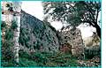 Gardiki: a low foothill of the Agios Mattheos mountain
range on which stand the ruined octagonal walls of a Byzantine
fortress. It was probably built during the 13th century, by Michael
II, Despot of Epirus, who also built the castle of Angelokastro,
at about the same time. It has eight decorated towers, built using
materials from ancient times. After Gardaki, the road continues
south, becomes a track, and reaches the north-west corner of Lake
Korission at Mesavrisi.
Gardiki: a low foothill of the Agios Mattheos mountain
range on which stand the ruined octagonal walls of a Byzantine
fortress. It was probably built during the 13th century, by Michael
II, Despot of Epirus, who also built the castle of Angelokastro,
at about the same time. It has eight decorated towers, built using
materials from ancient times. After Gardaki, the road continues
south, becomes a track, and reaches the north-west corner of Lake
Korission at Mesavrisi.
 Lake
Korission: actually a lagoon, it is long and narrow and extends
over an area of 6000 stremmata (1500 acres), in which the local
communities have applied systematic methods of fish farming. With
the Ionian Sea washing across a spit of land on to Halikounas
Beach, it is a magical spot, where sea and sand dunes blend, enhanced
by fantastic sunsets. The track runs on and ends where the lake
empties into the sea. Here, beside the ranger’s cabin with
its three guard dogs, there is a small wooden bridge, which carries
you into a unique forest where cedars grow on dunes dotted with
white lilies and 14 species of orchid. It is not hard to find
the footpath through the forest, which leads eventually to the
northern end of Agios Georgios Beach. The entire area, from the
lake to the far edge of the forest, constitutes an important wetlands
habitat, where 126 different kinds of birds have been observed.
In just one day, 1700 widgeons and 300 cormorants were counted,
while the endangered Great White Egret numbers over 90.
Lake
Korission: actually a lagoon, it is long and narrow and extends
over an area of 6000 stremmata (1500 acres), in which the local
communities have applied systematic methods of fish farming. With
the Ionian Sea washing across a spit of land on to Halikounas
Beach, it is a magical spot, where sea and sand dunes blend, enhanced
by fantastic sunsets. The track runs on and ends where the lake
empties into the sea. Here, beside the ranger’s cabin with
its three guard dogs, there is a small wooden bridge, which carries
you into a unique forest where cedars grow on dunes dotted with
white lilies and 14 species of orchid. It is not hard to find
the footpath through the forest, which leads eventually to the
northern end of Agios Georgios Beach. The entire area, from the
lake to the far edge of the forest, constitutes an important wetlands
habitat, where 126 different kinds of birds have been observed.
In just one day, 1700 widgeons and 300 cormorants were counted,
while the endangered Great White Egret numbers over 90.
Alonaki: a small natural harbour at the
southern tip of Lake Korission, just as lovely as everything else
in this region. To reach it, follow the lake road south to a stretch
right on the sea, with a view of the bay.
 Chlomotiana,
Chlomos, Agios Dimitrios, Kato Spilaio: returning to the main
road, the National Lefkimmi Road, you proceed south, passing turnings
to Chlomotiana, Chlomos, Agios Dimitrios and Kato Spilaio, pretty
villages set on low hills with views of the surrounding countryside.
Chlomos was the home of Thomas Palaiologos, brother of the last
Byzantine emperor and last Despot of Epirus after the occupation
of the Peloponnese by the Turks.
Chlomotiana,
Chlomos, Agios Dimitrios, Kato Spilaio: returning to the main
road, the National Lefkimmi Road, you proceed south, passing turnings
to Chlomotiana, Chlomos, Agios Dimitrios and Kato Spilaio, pretty
villages set on low hills with views of the surrounding countryside.
Chlomos was the home of Thomas Palaiologos, brother of the last
Byzantine emperor and last Despot of Epirus after the occupation
of the Peloponnese by the Turks.
Argyrades: at a distance of 33 kilometres
from Corfu Town, it is a substantial village with a population
of 2000 inhabitants. The alleyways, the arcades and the architectural
style of the houses are strongly reminiscent of the Venetian era.
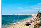 Agios
Georgios: just before the village of Argyrades, a road to
the right runs down to the beach of Agios Georgios. Essentially
Halikounas and Agios Georgios are one huge beach, 10 kilometres
in length, with sand dunes, fine sand and shallow water. In such
a vast expanse, you can be sure of finding a secluded spot to
yourself; even at the height of the tourist season. In the centre
of Agios Georgios, though, things are somewhat different: hotels
and rented accommodation, restaurants and bars, ski, jet-ski,
paragliding, parachuting, volleyball, and, as you can imagine,
people everywhere. In the middle of Argyrades a road junction
is signposted to Neohoraki, Roumanades, Vassilatika, Kouspades,
Korakades and Petriti, all villages on the east coast and all
well worth a visit.
Agios
Georgios: just before the village of Argyrades, a road to
the right runs down to the beach of Agios Georgios. Essentially
Halikounas and Agios Georgios are one huge beach, 10 kilometres
in length, with sand dunes, fine sand and shallow water. In such
a vast expanse, you can be sure of finding a secluded spot to
yourself; even at the height of the tourist season. In the centre
of Agios Georgios, though, things are somewhat different: hotels
and rented accommodation, restaurants and bars, ski, jet-ski,
paragliding, parachuting, volleyball, and, as you can imagine,
people everywhere. In the middle of Argyrades a road junction
is signposted to Neohoraki, Roumanades, Vassilatika, Kouspades,
Korakades and Petriti, all villages on the east coast and all
well worth a visit.
Neohoraki: settled in the 19th century
by Albanians: the ‘Gazetta’ of 1847 refers to the ‘Neocori
Albanese’.
Petriti: in ancient times called Egripos,
it is a seaside village with fish tavernas, a view towards the
mainland, and a rich history. It belonged to the Byzantine landowner
of the region, Petriti or Petretino, who granted the village to
the Palatianos family, probably as a dowry. A Byzantine tower
belonging to this family remains intact. The foundations of a
brick-built structure five metres in diameter, dating from Roman
times, were probably those of a grain store or a cistern.
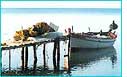 Boukari:
also a seaside village with tavernas right on the water’s
edge, located just north of Petriti. Archaeological studies mention
the existence of a Neolithic settlement here.
Boukari:
also a seaside village with tavernas right on the water’s
edge, located just north of Petriti. Archaeological studies mention
the existence of a Neolithic settlement here.
Korakades: which has ancient Hellenistic
origins, suffered a severe landslide some 30 years ago, causing
the inhabitants to move down to Petriti, taking with them their
traditional customs.

